


This post is coming in 3 parts, given the extent of the research and depth of the material.
Part 1: The Water Problem
Part 2: The Electricity Problem
Part 3: The Investment Opportunities
Reservoirs at record lows, a wildfire-driven flood at the Grand Canyon, and why this reaches far past Arizona.
Heavy assets, low obsolescence. That’s the HALO framework I keep coming back to in this space: physical, hard-to-replace infrastructure that holds up when something breaks, whether the break is geopolitical, financial, or hydrological. Goldman Sachs put a name and a research desk behind the same idea back in February. I’d been building portfolios around it for over a year before that. This week handed me an unusually concrete reason to add water to the list. The Colorado River water crisis is real and means we should examine this for its impact on our clients’ investment portfolios.
One of my favorite places is the Grand Canyon. I’ve white-water rafted it a couple of times, hiked to the bottom, and hiked to the top. I’ve stayed in the cabins on the North Rim, and I’ve stayed in the lodge on the South Rim. I’ve even ridden a mule named Rufus to the bottom and up. Whenever there’s news out of the canyon, I take note. I’m honestly not sure when I’ll get to visit again while I’m still young enough to enjoy it the way I have in the past, given the damage to both rims over the past two years.
On Saturday, flash floods tore through the Grand Canyon’s Bright Angel Canyon, funneled downhill by ground still stripped bare from last year’s wildfire on the closed North Rim. They destroyed nearly every footbridge on Bright Angel Creek. A debris flow even dammed the Colorado River itself, closing it to boat traffic above Phantom Ranch. Two people are confirmed dead, one still missing, and roughly 80 people had to be evacuated by helicopter. The flood also wrecked close to 40% of the pipeline that supplies water to the South Rim. This is part of the overall Colorado River water crisis.
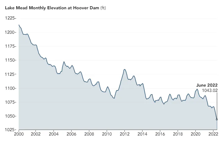
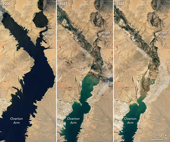
Upstream, Lake Powell closed August at 22% of capacity, its lowest point ever. Lake Mead closed at 26%, also a record low. I’ve watched this river’s decline as a talking point for years. This is Part 1 of a three-part series. This piece covers what’s actually happening to the river itself and why it reaches so much further than Arizona. Part 2 covers the strain this is putting on the power grid seven states depend on. Part 3 is where I get into what I actually think it means for a portfolio.
How the Colorado River Got Here
The Colorado River supplies roughly 40 million people across seven states and Mexico. Three reservoirs hold most of its stored water: Lake Powell, Lake Mead, and Flaming Gorge. This year’s collapse traces to the worst Upper Basin snowpack on record. Colorado’s peak snow water content hit just 51% of median in March, the lowest since satellite records began in the 1980s. Then it melted off roughly four weeks early, into soil so dried out by years of drought that it soaked up the meltwater before it ever reached a stream. Inflow into Lake Powell came in around 18% of average for the year, adding to the Colorado River water crisis.
The roots of this Colorado River water crisis go back a century. The Colorado River Compact of 1922 divided the river’s water among seven states. Negotiators used flow measurements from an unusually wet stretch of years. They assumed the river would deliver far more water than it actually does. The river’s long-term average flow is closer to 14 million to 15 million acre-feet a year. Basin-wide use has run closer to 13 million to 14 million acre-feet against actual flows nearer 12 million. We’ve been writing checks the river can’t cash for a hundred years, and this year exposed just how thin the cushion has become.
What “Deadpool” Actually Means, and What It Doesn’t
“Deadpool” gets thrown around loosely (and we are not discussing movies, here), so let me be precise, because the precise version is actually more useful for an investor than the scary version. Dead pool is the elevation at which a reservoir can no longer release water downstream by gravity at all. For Lake Powell that’s 3,370 feet. For Lake Mead it’s 895 feet. Both lakes are still roughly 145 to 150 feet above those lines, and the Bureau of Reclamation’s own modeling puts the probability of either reservoir actually reaching dead pool through water year 2030 at zero.
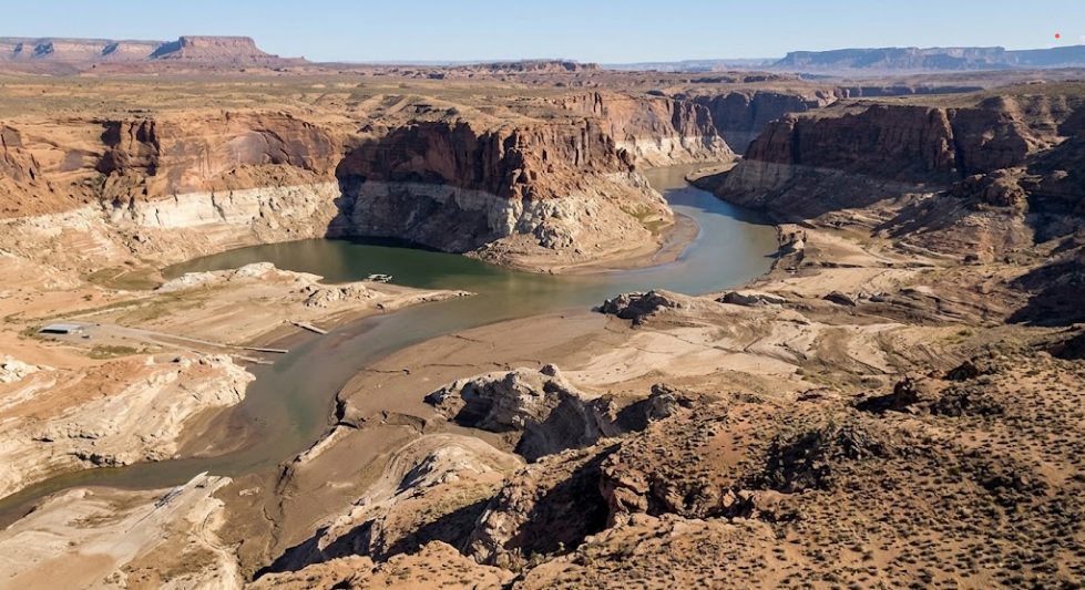
The real, current risk is a different and less dramatic threshold: minimum power pool, the elevation below which hydropower turbines can’t run. Glen Canyon Dam’s is 3,490 feet, and Powell sits only about 28 to 30 feet above it. Hoover Dam’s official minimum power pool is 950 feet, but the more meaningful line is 1,035 feet, where 12 of Hoover’s 17 turbines aren’t designed to operate and generating capacity drops by roughly 70%. Lake Mead closed August only about 4 feet above that line. This is the gap that matters right now. It’s why Reclamation has already cut Glen Canyon’s releases and pulled emergency water from upstream Flaming Gorge Reservoir just to protect it.
As former Interior official Anne Castle put it, what’s concerning isn’t an imminent dead river. It’s that “we’ve used up our storage buffer and allowed the reservoir to get this low” in the first place.
I want to be careful here, though, not to wave away the tail risk just because the official number is zero. Reclamation’s models are built on historical hydrology, and this year is a reminder of how fast those models can be overtaken by events. A year ago, nobody’s official forecast had Colorado’s snowpack bottoming out at the lowest level since satellite records began, or Lake Powell’s inflow collapsing to 18% of average. “Zero probability through 2030” is a real, defensible modeling output, and I’d treat it as the best available estimate, not a guarantee. Other research isn’t nearly as reassuring.
A 2025 peer-reviewed study in Nature Communications built its own climate-driven water-budget model, separate from Reclamation’s, and found that under current policy, Lake Powell and Lake Mead each carry an 83% to 85% cumulative probability of reaching dead pool at least once before 2060, rising to 96% to 97% by 2100. Even the most protective alternative policy the study tested still carried a 45% cumulative risk by 2060. That’s not a direct contradiction of Reclamation’s number. It’s measuring cumulative risk over a 35 to 75 year window against Reclamation’s rolling five-year snapshot. But it shows the structural long-run risk is nowhere near zero once recent climate trends get modeled explicitly instead of drawn from historical averages.
A handful of university and advocacy groups, the Getches-Wilkinson Center at CU Boulder, ASU’s Kyl Center, and the Glen Canyon Institute, have separately flagged that the near-term storage cushion is thinner than official messaging suggests. Their running “system crash” analysis uses a simple year-by-year math problem, current storage plus expected inflow minus expected use, rather than a full climate model.
Their September 2025 report on the Colorado River water crisis found Lake Powell and Lake Mead together held 6.3 million acre-feet of storage genuinely available above Reclamation’s protection elevations, and its conservative repeat-of-2025 scenario projected that cushion falling to roughly 3.6 million acre-feet by late summer 2026, nearly half gone in a single year. Their June 2026 update modeled a dry water year 2027 draining the cushion to just 3.63 million acre-feet, against a wet year only rebuilding it to 11.05 million acre-feet, which the researchers themselves framed as buying less than two years of room, not fixing anything. Their conclusion both times: current cuts aren’t enough, a wet year is a reprieve and not a fix, and absent voluntary cuts, Interior will have to act on its own.
The Glen Canyon Institute took a more illustrative approach, projecting Lake Powell’s level forward using two real historical five-year stretches, the 2000-2004 drought and 2017-2021, as a demonstration rather than a forecast. It separately noted that Reclamation’s own environmental review found 4% to 8% of its modeled scenarios hitting critical elevations through 2026 alone.
Actual dead pool at either dam would be the kind of low-probability, high-consequence event I wrote about in Black Swans in the Room, and a Colorado River water crisis wasn’t on that list when I wrote it. Given how severe the consequences would be, it belongs on the watch list now, even if it takes until 2060 to work its way to the top of it.
If Dead Pool Actually Happened, Here’s Who Runs Out First
None of that water reaches Arizona, Southern California, or Mexico directly from below the Grand Canyon. Everything for those three has to pass through Hoover Dam first, refill Lake Havasu, and travel on to the Central Arizona Project, the Colorado River Aqueduct, and Mexico’s Morelos Dam. Dead pool at 895 feet means water sits below Hoover’s intake towers and can’t move through the dam by gravity at all. Unlike Las Vegas, none of these three built a deeper mechanical straw of their own, so a true dead pool would starve every downstream intake in sequence.
Arizona would fall back on groundwater banked over decades by the Arizona Water Banking Authority, plus a slate of desalination-and-exchange projects working through the state’s Water Infrastructure Finance Authority, mostly plants on the Sea of Cortez or California coast that swap desalinated water for a share of Mexico’s or California’s river allocation. Those proposed volumes run 50,000 to 500,000 acre-feet a year, a small fraction of Arizona’s roughly 2.8 million acre-feet entitlement, and none of them arrive before 2028. Most won’t until the early to mid-2030s.
Southern California is the best hedged of the three. The Metropolitan Water District’s portfolio also includes the State Water Project, large local groundwater reserves, recycling, and Carlsbad desalination, which has cut San Diego’s import dependence from over 90% in the 1990s to roughly 40% today. Still, no MWD shortage plan currently addresses a full dead-pool scenario, only partial-shortage tiers well short of that.
Mexico is the most exposed of the three to this Colorado River water crisis. Morelos Dam supplies about 95% of Mexicali, Tecate, and Tijuana’s water, with no comparable domestic backup, and the US already denied an emergency delivery request in 2025. Its main hedge is the same desalination-exchange concept Arizona is pursuing, and that requires a new binational agreement that doesn’t exist yet.
There’s no existing infrastructure fix for any of the three if dead pool truly hits. That’s exactly why the ongoing negotiations, not just the hydrology, are what’s really standing between the basin and this scenario. Reclamation’s own preferred “Maximum Flexibility” alternative avoids dead-pool-driven cuts in 91% of its modeled futures, against just 30% under no policy change at all.
The Ground Is Literally Sinking
The groundwater backup plan I just described comes with its own asterisk. As Colorado River shortages push farmers and cities to pump more groundwater, aquifers in Arizona and California’s San Joaquin Valley are physically collapsing. One spot near Willcox, Arizona has sunk nearly 11.6 feet since 1969, and the pattern already spans more than 1,200 square miles across 25 distinct subsidence zones in Arizona alone. California’s San Joaquin Valley is sinking at a record pace for the same reason. This isn’t cosmetic. It damages canals, well casings, roads, and building foundations, and it permanently reduces how much water the aquifer can ever hold again. The groundwater everyone, myself included as I wrote earlier, keeps pointing to as the fallback plan is itself a depleting, partly non-renewable resource. It’s not a steady-state buffer you can draw down one decade and refill the next.
The Wildfire Connection, and Where It’s Genuinely Contested
This is where the Colorado River water crisis story gets interesting for investors, and where I want to be careful not to oversell a clean narrative. Wildfire is becoming a second driver of the basin’s water problems alongside drought, and the damage runs in two very different directions. But what actually caused the Grand Canyon flood is more contested than most news coverage suggests.
The Grand Canyon, This Week
The 2025 Dragon Bravo Fire burned roughly 150,000 acres of the Grand Canyon and Kaibab National Forest, an area close to the size of the city of Chicago, and closed lodging on the North Rim for the season. A federal Burned Area Emergency Response assessment afterward warned that runoff from the burn scar could run two to eight times higher than normal, and flagged upper Bright Angel Creek specifically as a debris-flow risk.
This past Saturday, up to two inches of rain fell on the North Rim in a series of storm waves, with the heaviest burst hitting roughly five inches an hour. Bright Angel Creek rose more than five feet in ten minutes. The flood destroyed nearly every footbridge on the creek, formed a nine-foot debris dam across the Colorado River itself, and damaged roughly 40% of the Transcanyon Waterline, the aging 1970s-era pipeline that is the sole water source for Grand Canyon Village. It was that pipeline’s second failure of the month. An earlier break on August 5 had already triggered conservation measures.
A $208 million rehabilitation of the line was already underway, and its 2027 completion target is now upended with no new date announced. The park is under Stage 4 water restrictions and has closed overnight lodging on the South Rim.
Here’s the honest complication. Whether the fire actually caused this flood is disputed among the people who study it. The National Weather Service’s post-event analysis concluded rainfall intensity, not the burn scar, was the dominant driver. Meteorologist Justin Johndrow said the fire “contributed maybe a little bit, but the majority of it was…the intensity of the rain.”
The BAER report itself had found most of the burned soil above Bright Angel Creek was low-to-moderate severity and hadn’t expected debris flows during a typical monsoon storm. Interior Secretary Doug Burgum, by contrast, publicly linked forest-management policy to the flood’s severity. My honest read: an extraordinary rain event landed on terrain made more flood-prone by fire, drought-fatigued soil, and steep canyon topography that funnels water violently regardless of what burned. I’d rather give you that nuance than a tidier story that isn’t quite true.
One thing isn’t in dispute. Pipeline damage at the Grand Canyon does not offset deadpool risk upstream in this Colorado River water c. They’re unrelated systems. The Transcanyon Waterline is local plumbing that pumps drinking water from a spring to South Rim buildings. It has nothing to do with how much water sits in Lake Powell.
This Wasn’t Isolated
2026’s monsoon season produced wildfire-linked flooding across the broader basin well beyond the Grand Canyon. In Colorado, the Gold Mountain and Aspen Acres fires triggered debris flows that repeatedly closed U.S. 550 through Red Mountain Pass and sent mud through the town of Beulah, where the Aspen Acres Fire had already destroyed more than 300 homes. In Utah, Governor Spencer Cox declared a state of emergency in July after more than 590 wildfires burned nearly 380,000 acres statewide; a Provo fire captain and his wife and three children died in flash flooding in Wayne County, and an August debris flow off a different burn scar shut down Interstate 15 near Beaver. This pattern, fire followed within a year or two by damaging debris flows, mirrors Colorado’s 2020 Grizzly Creek Fire, whose burn scar closed Interstate 70 through Glenwood Canyon repeatedly the following year.
That pattern points to two distinct kinds of cost: emergency repair, fixing broken pipelines and detecting leaks fast, and a slower-moving long tail, monitoring water quality and treating sediment-fouled supplies for years after a fire. Both are real. I’ll get into who actually profits from each, if anyone, in Part 3.
This Isn’t Just Arizona’s Problem
I think this deserves real portfolio weight, once you look past the two famous lakes. But I also want to show you where the popular version of this story gets specific numbers wrong, because a few of them are wrong in ways that matter for what you’d actually invest in.
The Cities
Las Vegas gets 90% of its water from the Colorado. The city’s so-called Third Straw, really two completed projects, an $817 million intake tunnel and a $522 million Low Lake Level Pumping Station, cost a combined $1.35 billion. The pumping station can draw water down to elevation 875 feet, which is below Hoover Dam’s own 895-foot dead pool line. Las Vegas, in other words, already built its way past the worst-case scenario for that lake.
Phoenix is a different story than the one usually told. The often-cited “$500 million Phoenix pipeline” is outdated. The actual Drought Pipeline Project, a 12-mile line moving Salt and Verde River water to North Phoenix neighborhoods, cost $280 million to $300 million, and it was finished in December 2022. It’s done. The real forward-looking spend is Phoenix’s six-year capital plan: $551 million for pipelines, $775 million for drought resiliency, and $765 million for a new advanced water purification facility that has federal funding secured but no construction started and no contractor named yet.
San Diego’s Pure Water program is further along and has real, named public-company exposure. Phase 1 carries a verified $1.76 billion cost, is about 90% complete, and is now expected to deliver purified drinking water in early 2027. Shimmick Corporation (SHIM) holds the largest single contract at $404.6 million, though the stock is thinly capitalized and volatile after a dilutive offering earlier this year.
The Farms
Agriculture’s share of the river gets cited constantly at 74%, and that figure is real, but understand what it’s measuring. It comes from a 2024 peer-reviewed study in Communications Earth & Environment, and it measures agriculture’s share of direct human consumption specifically. Measured against total basin consumption, which also counts reservoir evaporation and riparian ecosystem use, agriculture’s share is 52%. Either way, alfalfa alone, grown mostly as cattle feed, uses more water than every city and industrial user in the basin combined, about 27% of total consumption.
The Upper Basin took real, involuntary cuts in 2025. Wyoming shut off irrigation on more than 163,000 acres in the Green River Basin, and on one river, priority reverted all the way back to an 1891 water right. Utah’s Uintah Basin ranchers had to shrink their herds after even senior 1861 water rights came up short. New Mexico’s San Juan-Chama project, which supplies Albuquerque and Santa Fe, got just 31% of normal, a record low. Colorado’s Dolores Water Conservancy District cut some users by 44%, and 2026 has been worse still, with its main reservoir running at 13% to 14% of full-service supply. This is a whole-river story, not a Phoenix story.
There’s a stranger collision happening in the Lower Basin too. The Imperial Valley’s Salton Sea region has real ambitions to become “Lithium Valley,” a domestic source of the lithium and geothermal power the country wants for EV batteries, and those ambitions just ran straight into the same water math. A California appeals court ruled in August 2026 that Imperial County’s approval of the Hell’s Kitchen lithium and geothermal project failed to show it had secured enough Colorado River water from the Imperial Irrigation District to sustain 50 years of operation, and sent the project back for further environmental review.
Proposed lithium and geothermal projects near the shrinking Salton Sea could need nearly four times the 25,000 acre-feet the district currently sets aside for all non-agricultural uses combined. The same river cuts threatening farmland are now threatening a domestic critical-minerals supply chain the country is counting on.
There is a lot of talk about conservation reducing the need for as much irrigation. That is not as easy as the proponents make it sound. Water economists (including Utah State University researchers) find that switching to “more efficient” irrigation (drip, sprinklers) often doesn’t save real water at all — a crop’s biological water need is mostly fixed, and “efficiency” gains can just get redirected into more acreage or fuller stands rather than leaving more water in the river.
What genuinely works without cutting output:
-
Canal seepage fixes — pure infrastructure waste, zero yield impact. The All-American and Coachella canal linings save ~93,700 acre-feet/year this way.
-
Evaporation-targeted on-farm methods (subsurface drip, tailwater recovery, precision leveling) — Imperial Irrigation District’s efficiency program targets 165,000–180,000 acre-feet/year on this basis while “maintaining crop production.”
-
Deficit irrigation on alfalfa specifically — alfalfa can go dormant and regrow, so a 2025 peer-reviewed study estimates 16–50% of its water use could be saved with modest yield impact concentrated in cattle feed, not direct human food.
-
Crop switching to less thirsty forage — preserves output in principle, but is the hardest lever to actually pull given entrenched cattle-feed markets and the economics of switching discussed more in depth below.
The honest ceiling: Reclamation and Pacific Institute analysis put realistic output-preserving efficiency savings at roughly 1 million acre-feet/year basin-wide — real, but only about a quarter to 40% of the 2.4–4 MAF/year actually needed to stabilize the system. Even Imperial Irrigation District, one of the most aggressive programs on the river, gets most of its conservation from fallowing (i.e., not planting land) and deficit irrigation that do reduce output, just voluntarily and for pay rather than by force. Fallowing and deficit irrigation programs have scaled more than crop switching as they let the farmer continue to get paid without redefining their crops and thereby shrinking their water rights and one of the farmer’s most valuable assets (more on this below).
The Tribes
Thirty federally recognized tribes in the basin hold rights to roughly 3.2 million to 3.8 million acre-feet a year, on the order of 22% to 29% of the basin’s total average annual supply. Historically they’ve used only about half of what they’re entitled to, mostly because many lack the pipelines, treatment plants, and canals to physically put that water to use. That’s changing. As of early 2026, 11 basin tribes still had unresolved or unquantified claims of unknown total size, and settlements are actively being finalized. The Navajo Nation’s pending Utah settlement alone would add 314,851 acre-feet a year of new entitlement.
Every acre-foot a tribe newly puts to use is an acre-foot that stops flowing to downstream non-tribal users. It’s a legally locked-in, growing draw on the system that has nothing to do with drought or snowpack, and it gets far less attention than reservoir levels do.
The Clock Already Rang Once, and Nevada Just Sued Over It
The old 2007 Interim Guidelines and 2019 Drought Contingency Plan expire at the end of this month. After three years of failed seven-state consensus, Interior Secretary Doug Burgum signed a Record of Decision on August 21 setting specific rules for 2027 and 2028: Lower Basin cuts of 1.25 million acre-feet a year, split roughly 760,000 for Arizona, 440,000 for California, and 50,000 for Nevada, plus a request for 700,000 more in voluntary conservation. The Upper Basin faces no mandatory reductions at all, only voluntary goals.
Nevada didn’t accept that. On August 24, the state, the Colorado River Commission of Nevada, and the Southern Nevada Water Authority sued to void the decision, arguing it violates federal administrative law and unfairly shields the Upper Basin while exposing southern Nevada to cuts of up to 213,556 acre-feet, more than 70% of its allocation, by the early 2030s. Arizona, by contrast, publicly accepted the decision as providing a measure of stability. No hearing date has been set. That lawsuit means the entire allocation framework could be reopened by litigation before it’s even implemented, which is exactly the kind of regulatory uncertainty that should make anyone sizing an investment position here go in with eyes open.
Could the River Ever Recover?
Two separate questions are worth untangling here. Could the reservoirs physically refill to their old levels, and could water use realistically be cut to match what actually flows into the system each year. Neither has a reassuring answer on the current trajectory.
The math starts with an allocation problem that predates climate change entirely. The 1922 Compact and everything built on it divides about 16.5 million acre-feet a year among the seven states and Mexico. That already exceeded the river’s full 1906-2024 average natural flow of roughly 14.6 million acre-feet. It’s now dramatically higher than the actual 21st-century average of about 12.2 million to 12.4 million acre-feet, an 18%-plus shortfall driven by two decades of what climate scientists call hot drought. The system was legally over-allocated relative to its own long-run average before global warming ever entered the picture. Warming has since made the gap between paper rights and wet water much worse.
A 2024 water-accounting study in Communications Earth & Environment, the same one behind the 74%-versus-52% agriculture figure earlier in this piece, found the basin was overconsumed, total human use exceeding actual runoff, in 16 of the 21 years from 2000 to 2020. Average total consumption ran around 19.3 million acre-feet against a shrinking supply, which is a real part of why the river has stopped reaching its own delta in Mexico most years. The delta was once a ~2 million-acre estuary, Aldo Leopold’s “milk and honey wilderness,” that started collapsing with the Hoover Dam (1936) and was devastated further as Glen Canyon Dam filled Lake Powell (1963-1981), shrinking it to roughly 10% of its original size
Reclamation’s own more conservative accounting, which counts consumptive use alone rather than full system losses, points the same direction: consumptive use fell from 13.8 million acre-feet in 2021 to 13.3 million in 2024, while flows over that period averaged only about 11.9 million. A structural deficit persists even after real conservation gains.
Refilling the Lakes Is a Math Problem With an Answer Nobody Likes
Multiple independent experts converge on an uncomfortable number. Assuming water use stays at today’s levels, it would take four to six consecutive, unusually wet years, on the order of 2011 or 2023, two of the best runoff years this century, to refill Lake Powell and Lake Mead. Some federal hydrologists put the true number at six to eight. Every one of those experts immediately attaches a caveat that it isn’t going to happen. Colorado State climate scientist Brad Udall called a run like that something he doesn’t “see even being remotely possible,” and a Reclamation hydrologist called six to eight such years in a row something that “probably isn’t very likely.”
A theoretical exercise makes the scale concrete. Erasing Lake Mead’s roughly 20-million-acre-foot deficit would take about two and a half years if every downstream release to California, Arizona, Nevada, and Mexico were shut off entirely, which will never happen. A more realistic path, improved management plus favorable weather, with deliveries continuing, runs 30 to 50 years, and even that assumes the weather cooperates. My honest read on “if ever”: a full return to pre-2000 levels may never happen under the current warming trajectory and legal use pattern. Not because refilling is physically impossible, but because it needs several exceptional wet years in a row stacked on cuts far deeper than anything negotiated to date, against a target that science and cycles say keeps moving in the wrong direction.
Drought Is Temporary. Aridification Is Permanent.
Aridification is the gradual, long-term transition of a region toward a permanently drier climate. Unlike a drought, which is a temporary dry spell that ends when rain returns, aridification represents a structural, baseline shift in the environment.
That’s the phrase Brad Udall and fellow climate scientist Jonathan Overpeck coined in a foundational 2017 paper that first used “hot drought” to describe what’s happening to this river. They believe that human-caused warming responsible for roughly a third to a half of the 19% flow decline observed from 2000 to 2014, and projected further warming could cut flows another 20% by 2050 and up to 35% by 2100 if precipitation stays flat. Their point is definitional, not just a bigger number: a hotter atmosphere pulls more moisture out of soil and snowpack before it ever becomes streamflow, so even a return to historically normal precipitation would no longer produce historically normal runoff.
Whatever your views on climate change, whether simply cyclical as some evidence suggests or man made as other evidence suggests, the fact is warmer weather is having an impact on increased evaporation.
That view isn’t unanimous. A 2024 NOAA-linked study found it more likely than not that flows from 2026 to 2050 will actually run 5% to 7% higher than the unusually dry 2000-2025 stretch, based on a forecast more favorable precipitation cycle. But even that more optimistic camp is describing a partial rebound within a still-depleted range, not a return to the 20th-century baseline. The broader science literature concludes basin flows are not likely to ever return to their previous normal.
The Physics Aren’t the Obstacle. The Politics Are.
Here’s the one genuinely hopeful fact in this section: physically, closing the gap is possible. Agriculture alone consumes roughly three-quarters of direct human water use in the basin, so a large enough shift from irrigation to conservation could help balance the books on paper. Unfortunately, closing the gap without any output loss is not possible as things stand. The alternative seems to be switching to growing a less water-intensive cattle feed that might cover the loss: sorghum, sudangrass, wheat, barley, oats, rye, teff — need roughly 30-60% less water than alfalfa.
Alfalfa‘s long growing season, self-fertilizing legume roots, and strong export demand (~20% of Western production goes overseas, much to Saudi Arabia and China dairies) make it unusually profitable per acre-foot of water in good price years — switching to grains is a real pay cut. In most basin states, a farmer’s legal water right is capped at their historical consumptive use. Switch to a lower-water crop, and the state can permanently shrink that right to match — with no guarantee of switching back or ever monetizing the saved water. Since that water right is often the farmer’s most valuable asset and retirement plan, growing the thirstiest crop is the economically rational move for the individual, even though it’s collectively costly. Alfalfa locks in for multiple years once planted, and the newer low-water alternatives lack established buyers, pricing history, or proven long-term yields, making them a genuine gamble for a working farm.
Multiple independent estimates converge on how much reduction is needed: stabilizing the system at today’s already-reduced flows needs a 13% to 20% cut in basin-wide use, roughly 2.4 million to 3.2 million acre-feet a year, with some 2026 estimates running as high as 4 million, about a quarter of total allocated volume. That target isn’t fixed either. The same research group projects the required cut could double to roughly a third of current use by 2050 as continued warming shrinks the achievable baseline further. The basin isn’t aiming at a stationary target. It’s trying to hit one that keeps receding.
Measured against what’s actually been agreed, the gap is stark. Arizona, California, and Nevada pledged 3 million acre-feet of cuts through 2026. The post-2026 framework calls for 1.25 million acre-feet a year in 2027 and 2028, rising toward 3 million in drier later years. California separately offered 440,000 acre-feet a year as part of a broader 1.5-million-acre-foot Lower Basin package that would include Mexico. Those commitments sit within or below the low end of the 2.4-million-to-4-million range researchers say is needed just to stabilize the system, which is why a recent academic assessment concluded current conservation efforts get the basin “only halfway to a solution.”
The bottom line for this section, and maybe for the whole piece: the physics of closing the gap aren’t the obstacle. Cutting agricultural use enough would balance the books but at the cost of crop loss and/or long-term monetary loss, but cutting is possible.
The real constraints are legal, since senior water rights, interstate compacts, and Mexico’s treaty guarantee are all hard to unwind quickly; economic, given the food security and farm-economy disruption already covered above; and political, since seven states and a foreign country all have to agree, repeatedly, to shrinking allocations.
Layer possible aridification or even a simple yet multi-decade warming cycle on top and the basin isn’t managing toward a fixed, achievable balance point. It’s negotiating cuts against a supply baseline that keeps eroding, which is the real reason a full return to historic reservoir levels looks unlikely on any near- or medium-term horizon.
What’s Next
This is a lot to sit with, and I haven’t even gotten to the power grid yet. Glen Canyon and Hoover Dam don’t just move water. They generate electricity for roughly 5 million people across seven states, and that system is under its own kind of strain right now. I’ve written that up separately in Part 2, since it deserves its own space rather than a rushed section tacked onto the end of this one.
Once you’ve got the full picture, water and power together, Part 3 is where I get into what I actually think this means for an investment portfolio: which of the obvious water stocks hold up to scrutiny, which don’t, and where I think the real, if smaller, opportunities are.
If you’re not a current BCNA client and want to talk through any of this and how we can manage your investments, reach out to Joel Wallace at [email protected] or call him at (217) 351-2870.
–Mark
Disclaimer: This post is for informational purposes only and should not be considered investment advice. The views expressed are my own analysis and opinions. Every investor’s situation is different, and you should conduct your own due diligence before investing in anything. You should consult with a qualified financial professional, like ourselves, before making any investment decisions. Past